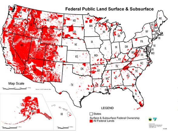
The red map, which we mentioned on the first page, shows much of the western USA in blood red ink and does not tell the truth! The bright red color is no coincidence. Red is what psychologists call a “trigger” color. Red is equated with threat and hazard!
… the land in the map is all colored the same. That gives a grossly simplistic picture of the how that landscape is managed. The map includes Yellowstone National Park, 29 Palms Marine Base, and the Pine Ridge Indian Reservation, for example. Those lands have vastly different mandates and management, but under ALC’s map, are all the same.
Compare the map with a similar one produced by the U.S. Geological Survey. It shows the same acreage, but with colors coded for military bases, wildlife refuges, Indian Reservations and national parks and forests. The brown, tan and light green of Fish and Wildlife Service, Bureau of Land Management and National Forest land tend to be of highest consequence for hunters and anglers, and are also the lands first targeted by ALC.
In other words, if you’re investigating the dispute around public land transfers and suddenly see a map filled with red coloring know you are being manipulated. Simply put, take what you are seeing with a massive grain of salt!
To read more about this provocative issue go to Outdoor Life. Don’t let anyone pull the wool over your eyes or a map over your good sense and what is right!
Featured Image via Outdoor Life/Wiki
They want total control of the high ground.
Can somebody explain why the Feds need to own almost the entire states of Nevada, Arizona and Utah?
The Feds can’t control any land in Texas, every base or Federal installation is leased from the state to the government, so this map is a lie!!!
Nuclear testing / radiation. Oh and aliens too haha